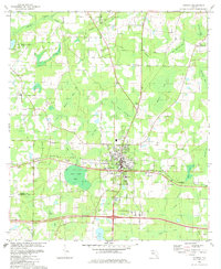
1982 Map of Bonifay
USGS Topo · Published 1982About this map
Bonifay serves as the focal point of this Holmes County study, showing the city's development along the Louisville and Nashville railroad corridor. The landscape is defined by an intricate network of wetlands and "bays," including Sand Path Bay, Bear Bay, and the expansive Gum Creek Swamp. These natural features dictated the placement of early settlements and agricultural clearings. The map reveals a community deeply rooted in its local institutions, evidenced by the numerous rural congregations such as Gully Springs Ch, New Smyrna Ch, and Mt Olive Ch. Cultural landmarks from the era are well-documented, including the Drive-In Theater west of town and the Fairgrounds to the east. The transition from traditional rural patterns to mid-century residential planning is visible in the emergence of the Dogwood Lakes Estate and several localized claypits that hint at the area's geological industry.
Find a feature on this map
54 named features on this map. Tap any name to fly to it.
Don’t see what you’re looking for? This feature index may not catch every label — zoom into the map to look around manually.
Map Details
Editions of this 1982 Bonifay Map
This is the sole edition of this map. No revisions or reprints were ever made.
Other maps of this area

1949 · Hinsons Cross Roads
USGS Topo · 1:24,000

1949 · Caryville
USGS Topo · 1:24,000

1950 · Hinsons Cross Roads
USGS Topo · 1:24,000

1950 · Caryville
USGS Topo · 1:24,000

1950 · Izagora
USGS Topo · 1:24,000

1950 · Chipley
USGS Topo · 1:24,000

1950 · Wausau
USGS Topo · 1:24,000

1950 · Esto
USGS Topo · 1:24,000

1950 · Poplar Head
USGS Topo · 1:24,000

1951 · Graceville
USGS Topo · 1:24,000