2022 Map of Bonnetsville
USGS Topo · Published 2022About this map
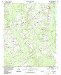
Bonnetsville and the surrounding Sampson County landscape are defined by a complex network of slow-moving coastal plain waterways, where the Great Coharie Cr and Little Coharie Cr drainage systems create a mosaic of wetlands and seasonal floodplains. The settlement pattern follows the higher ground between these basins, centered on the east-west corridor of Roseboro Hwy. Small rural communities like Concord, Snow Hill, and McDaniels are interspersed with family-named landmarks and water bodies such as Williams Pond and Halls Pond. The presence of Hillcrest Memorial Park near the northeastern edge and the established town of Roseboro to the west suggests a region that maintains its traditional agricultural character while serving as a residential anchor for the county. Significant wetland features like Bearskin Swamp illustrate the hydrologic challenges that have historically influenced road placement and land use in this part of North Carolina.
Find a feature on this map
70 named features on this map. Tap any name to fly to it.
Don’t see what you’re looking for? This feature index may not catch every label — zoom into the map to look around manually.
Map Details
Editions of this 2022 Bonnetsville Map
This is the sole edition of this map. No revisions or reprints were ever made.