1972 Map of Boyce
USGS Topo · Published 1977About this map
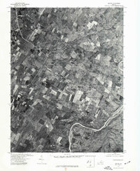
Boyce and the surrounding agricultural landscape of Clarke County are captured here during the early 1970s. This orthophotoquad, derived from aerial photography taken in April 1972, provides a visual record of the region's land use patterns, showing a patchwork of cultivated fields and woodlots. The Shenandoah River snakes through the southeastern portion of the map, defining the local topography and drainage. This specific format emphasizes the physical layout of the land over traditional topographic symbols, making it possible to identify individual farmsteads and the compact village footprints of both Boyce and Millwood. The distribution of structures along the road network reflects the long-standing rural development typical of this part of Virginia before more modern suburban expansion.
Find a feature on this map
3 named features on this map. Tap any name to fly to it.
Don’t see what you’re looking for? This feature index may not catch every label — zoom into the map to look around manually.
Map Details
Editions of this 1972 Boyce Map
This is the sole edition of this map. No revisions or reprints were ever made.
Other maps of this area

1884 · Harpers Ferry
USGS Topo · 1:125,000

1891 · Harpers Ferry
USGS Topo · 1:125,000

1893 · Luray
USGS Topo · 1:125,000

1893 · Harpers Ferry
USGS Topo · 1:125,000

1894 · Warrenton
USGS Topo · 1:125,000

1894 · Winchester
USGS Topo · 1:125,000

1905 · Luray
USGS Topo · 1:125,000

1916 · Berryville
USGS Topo · 1:62,500

1938 · Winchester
USGS Topo · 1:48,000

1939 · Front Royal
USGS Topo · 1:48,000