1924 Map of Bramwell
USGS Topo · Published 1956About this map
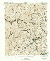
The Norfolk and Western RR snakes through the deep valleys of the West Virginia coalfields, connecting a dense string of industrial settlements along the Elkhorn Creek. This 1924 cultural revision captures the height of the region's mining economy, documenting the rapid succession of company towns from Vivian and Keystone to Switchback and Maybeury. The landscape is a complex network of ridgelines like Indian Ridge and North Fork Ridge that dictated the layout of rail spurs and early mountain roads. Cultural markers of the era are abundant, from the Dearing PO and Bailey Chapel to remote educational outposts like the Shady Grove School. The map also traces the boundary where the coal country of McDowell and Mercer counties meets the Virginia state line at Abbs Valley Ridge, illustrating the era's reliance on both the river-valley rails and the high-elevation gaps like Peeled Chestnut Gap.
Find a feature on this map
138 named features on this map. Tap any name to fly to it.
Don’t see what you’re looking for? This feature index may not catch every label — zoom into the map to look around manually.
Map Details
Editions of this 1924 Bramwell Map
This is the sole edition of this map. No revisions or reprints were ever made.
Other maps of this area

1887 · Pocahontas
USGS Topo · 1:125,000

1891 · Tazewell
USGS Topo · 1:125,000

1891 · Pocahontas
USGS Topo · 1:125,000

1891 · Oceana
USGS Topo · 1:125,000

1891 · Raleigh
USGS Topo · 1:125,000

1893 · Oceana
USGS Topo · 1:125,000

1894 · Pocahontas
USGS Topo · 1:125,000

1895 · Tazewell
USGS Topo · 1:125,000

1895 · Pocahontas
USGS Topo · 1:125,000

1897 · Tazewell
USGS Topo · 1:125,000