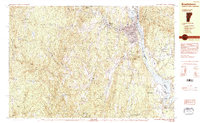
1984 Map of Brattleboro
USGS Topo · Published 1984About this map
The Connecticut River serves as a defining boundary between Windham Co and Cheshire Co, anchoring a landscape where industrial infrastructure and early New England history sit side-by-side. The presence of the Vermont Yankee Nuclear Power Sta in the south near Vernon contrasts with the deep local history marked by The Old Muster Ground and several small rural hamlets like Whitneyville and Guilford Center. Along the riverbanks, the Central Vermont and Boston and Maine railroads reflect the region's transport legacy, while Brattleboro itself emerges as a primary hub of civic activity, housing the Brattleboro Retreat (Hospital) and the Brattleboro Country Club. The map's western reaches transition into the elevations of Governors Mountain and Jolly Mtn, where numerous cemeteries like King Cem and Mather Cem suggest the long-standing family settlements of these Vermont hillsides.
Find a feature on this map
74 named features on this map. Tap any name to fly to it.
Don’t see what you’re looking for? This feature index may not catch every label — zoom into the map to look around manually.
Map Details
Editions of this 1984 Brattleboro Map
2 editions found
Other maps of this area

1886 · Hawley
USGS Topo · 1:62,500

1887 · Warwick
USGS Topo · 1:62,500

1889 · Warwick
USGS Topo · 1:62,500

1889 · Wilmington
USGS Topo · 1:62,500

1890 · Hawley
USGS Topo · 1:62,500

1890 · Greenfield
USGS Topo · 1:62,500

1891 · Wilmington
USGS Topo · 1:62,500

1891 · Brattleboro
USGS Topo · 1:62,500

1893 · Brattleboro
USGS Topo · 1:62,500

1894 · Greenfield
USGS Topo · 1:62,500