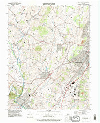
1989 Map of Bridgewater
USGS Topo · Published 1995About this map
Bridgewater College and James Madison University anchor the southern and eastern edges of this Shenandoah Valley landscape, which shows the region in the late 1980s. The area is defined by a dense network of limestone-spring-fed waterways, including the winding Cooks Creek, Muddy Creek, and the Dry River. These streams historically supported the agricultural hamlets of Dayton, Hinton, and Mount Clinton seen here.
Find a feature on this map
50 named features on this map. Tap any name to fly to it.
Don’t see what you’re looking for? This feature index may not catch every label — zoom into the map to look around manually.
Map Details
Editions of this 1989 Bridgewater Map
This is the sole edition of this map. No revisions or reprints were ever made.
Other maps of this area

1892 · Franklin
USGS Topo · 1:125,000

1892 · Woodstock
USGS Topo · 1:125,000

1892 · Harrisonburg
USGS Topo · 1:125,000

1894 · Staunton
USGS Topo · 1:125,000

1896 · Franklin
USGS Topo · 1:125,000

1922 · Fort Seybert
USGS Topo · 1:48,000

1924 · Fort Seybert
USGS Topo · 1:62,500

1941 · Harrisonburg
USGS Topo · 1:62,500

1943 · Harrisonburg
USGS Topo · 1:62,500

1944 · Parnassus
USGS Topo · 1:62,500