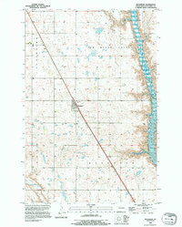
1990 Map of Buchanan
USGS Topo · Published 1995About this map
Buchanan stands as the primary settlement on this North Dakota prairie landscape, situated along a north-south corridor marked by Highway 52 and Highway 281. The map reflects a landscape defined by its water management and agricultural grid, where the wide James River Valley is dominated by the expansive James River Reservoir along the eastern edge. This reservoir creates a stark contrast to the surrounding terrain of Plainview, which is dotted with numerous small potholes and wetlands characteristic of the glacial till in Stutsman County. Local history is anchored by the small Cem located just north of the town center, while the rectangular township and range lines of R 65 W and R 64 W delineate the organized rural settlement pattern of the late twentieth century.
Find a feature on this map
10 named features on this map. Tap any name to fly to it.
Don’t see what you’re looking for? This feature index may not catch every label — zoom into the map to look around manually.
Map Details
Editions of this 1990 Buchanan Map
This is the sole edition of this map. No revisions or reprints were ever made.
Other maps of this area

1896 · Jamestown
USGS Topo · 1:125,000

1900 · Pingree
USGS Topo · 1:125,000

1900 · Pingree
USGS Topo · 1:62,500

1950 · Buchanan
USGS Topo · 1:24,000

1950 · Fried
USGS Topo · 1:24,000

1951 · Jamestown
USGS Topo · 1:24,000

1951 · Fried
USGS Topo · 1:24,000

1951 · Pingree
USGS Topo · 1:24,000

1951 · Eldridge NW
USGS Topo · 1:24,000

1952 · Buchanan
USGS Topo · 1:24,000