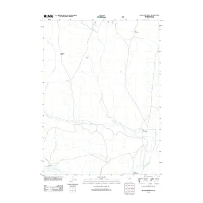
2012 Map of Buckhorn Ridge
USGS Topo · Published 2012About this map
Buckhorn Ridge dominates this high-altitude cattle country of Elko County, where the 2012 landscape reflects a century of ranching operations. The area is defined by a network of seasonal water sources and named pastures, including Buckhorn Pasture and the aptly named Elk Meadows. Local infrastructure is anchored by the O'Neil Ranch and the nearby O'Neil Post Office, illustrating the sparse but enduring settlement pattern of the O'Neil Basin. Drainage systems like Pole Creek and Canyon Creek carve through the terrain, eventually feeding into the South Fork Salmon Falls Creek at the southern edge of the survey. The map details remote outposts such as Bull Camp and Cottonwood Ranch, connected by rugged paths like the O'Neil Basin Rd, marking a region where life and work follow the contours of the high desert and the availability of water at sites like Buckhorn Spring.
Find a feature on this map
17 named features on this map. Tap any name to fly to it.
Don’t see what you’re looking for? This feature index may not catch every label — zoom into the map to look around manually.
Map Details
Editions of this 2012 Buckhorn Ridge Map
This is the sole edition of this map. No revisions or reprints were ever made.
Other maps of this area

1955 · Wells
USGS Topo · 1:250,000

1957 · Contact
USGS Topo · 1:62,500

1957 · Elk Mountain
USGS Topo · 1:62,500

1958 · Wells
USGS Topo · 1:250,000

1961 · Wells
USGS Topo · 1:250,000

1968 · Hubbard Basin
USGS Topo · 1:24,000
1968 · Gilmer Ranch
USGS Topo · 1:24,000
1970 · Sun Creek NW
USGS Topo · 1:24,000
1981 · Jarbidge Mts
USGS Topo · 1:100,000

1982 · Jackpot
USGS Topo · 1:100,000