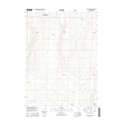
2015 Map of Buckhorn Ridge
USGS Topo · Published 2015About this map
Humboldt National Forest land defines this corner of Elko County, where high-altitude drainages and grazing grounds dominate the landscape. Named for the prominent Buckhorn Ridge, the terrain is carved by complex water systems including Canyon Cr and the S Fork Salmon Falls Cr. The map reveals a land utilized for seasonal ranching and hunting, with distinct names like Buckhorn Pasture and Elk Meadows suggesting the area's practical ecological value. Water remains a critical resource in this high-desert environment, marked by sites such as Buckhorn Spring and Elk Spring. The inclusion of Choke-A-Man Draw and Jaboonek Flat provides specific local identifiers for those researching the geography of the Salmon River Range.
Find a feature on this map
20 named features on this map. Tap any name to fly to it.
Don’t see what you’re looking for? This feature index may not catch every label — zoom into the map to look around manually.
Map Details
Editions of this 2015 Buckhorn Ridge Map
This is the sole edition of this map. No revisions or reprints were ever made.
Other maps of this area

1955 · Wells
USGS Topo · 1:250,000

1957 · Contact
USGS Topo · 1:62,500

1957 · Elk Mountain
USGS Topo · 1:62,500

1958 · Wells
USGS Topo · 1:250,000

1961 · Wells
USGS Topo · 1:250,000

1968 · Hubbard Basin
USGS Topo · 1:24,000
1968 · Gilmer Ranch
USGS Topo · 1:24,000
1970 · Sun Creek NW
USGS Topo · 1:24,000
1981 · Jarbidge Mts
USGS Topo · 1:100,000

1982 · Jackpot
USGS Topo · 1:100,000