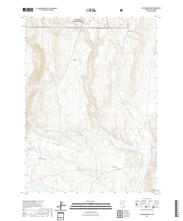
2021 Map of Buckhorn Ridge
USGS Topo · Published 2021About this map
Buckhorn Ridge stands as the central topographical feature in this high-altitude corner of Elko County, marking the divide within the Humboldt National Forest. This modern survey reveals a landscape defined by livestock management and watershed patterns, where wide-open spaces like Buckhorn Pasture and Jaboonek Flat provide grazing grounds between steep draws. The intricate network of drainage is anchored by the North Fork Salmon Falls Cr and Canyon Cr, which carve through the basin and provide vital water sources like Buckhorn Spring.
Find a feature on this map
25 named features on this map. Tap any name to fly to it.
Don’t see what you’re looking for? This feature index may not catch every label — zoom into the map to look around manually.
Map Details
Editions of this 2021 Buckhorn Ridge Map
This is the sole edition of this map. No revisions or reprints were ever made.
Other maps of this area

1955 · Wells
USGS Topo · 1:250,000

1957 · Contact
USGS Topo · 1:62,500

1957 · Elk Mountain
USGS Topo · 1:62,500

1958 · Wells
USGS Topo · 1:250,000

1961 · Wells
USGS Topo · 1:250,000

1968 · Hubbard Basin
USGS Topo · 1:24,000
1968 · Gilmer Ranch
USGS Topo · 1:24,000
1970 · Sun Creek NW
USGS Topo · 1:24,000
1981 · Jarbidge Mts
USGS Topo · 1:100,000

1982 · Jackpot
USGS Topo · 1:100,000