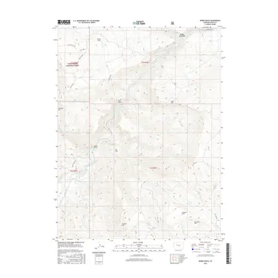
2016 Map of Burns South
USGS Topo · Published 2016About this map
Derby Junction marks a significant waypoint along the Colorado River in Eagle County, where the river valley carves a path through the southern reaches of the White River National Forest. The landscape is defined by dramatic elevation changes, ranging from the flat expanses of Jack Flats and the high agricultural plateau of Derby Mesa to the prominent peaks of Greenhorn Mtn and Porphyry Mtn. This 2016 survey illustrates the modern management of water and transit in this high-altitude environment, featuring the S Derby Ditch irrigation system and the Price Reservoir. Access to this back-country terrain is facilitated by the Colorado River Rd and the Red Dirt Bridge, which serves as a vital crossing point. The map also highlights the complex drainage network of the Red Dirt Basin, with numerous seasonal and perennial flows like Posey Cr and Alamo Cr feeding into the main river channel.
Find a feature on this map
33 named features on this map. Tap any name to fly to it.
Don’t see what you’re looking for? This feature index may not catch every label — zoom into the map to look around manually.
Map Details
Editions of this 2016 Burns South Map
This is the sole edition of this map. No revisions or reprints were ever made.
Other maps of this area

1927 · Glenwood Springs
USGS Topo · 1:125,000

1930 · Glenwood Springs
USGS Topo · 1:125,000

1957 · Leadville
USGS Topo · 1:250,000

1959 · Leadville
USGS Topo · 1:250,000

1960 · Leadville
USGS Topo · 1:250,000

1962 · Leadville
USGS Topo · 1:250,000

1962 · Gypsum
USGS Topo · 1:24,000

1962 · Eagle
USGS Topo · 1:24,000

1964 · Leadville
USGS Topo · 1:250,000

1972 · Blue Hill
USGS Topo · 1:24,000