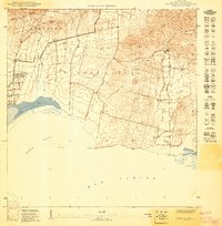
1949 Map of Cabo Rojo NE
USGS Topo · Published 1949About this map
Llanos Costa and the jagged ridges of Sierra Bermeja define the coastal landscape of this 1949 survey. The map details a period of transition along the southwest coast of Puerto Rico, where the traditional salt-producing Salinas near Bahía Sucia and Salinas Pitajaya exist alongside developing rural communities. Small settlements like Corozo and Las Palmas are documented with individual structures, reflecting the local agrarian and coastal economy before modern development. In the western portion, the Iglesia de Cristo Rey serves as a local landmark, while the topography rises steeply from the plains into the Lomas de Boquerón and Peñones de Melones. The network of paths and small roads suggests a landscape shaped by local travel between the coast and the inland peaks like Cerro Tinaja.
Find a feature on this map
16 named features on this map. Tap any name to fly to it.
Don’t see what you’re looking for? This feature index may not catch every label — zoom into the map to look around manually.
Map Details
Editions of this 1949 Cabo Rojo NE Map
This is the sole edition of this map. No revisions or reprints were ever made.
Other maps of this area

1935 · Puerto Real
USGS Topo · 1:25,000

1937 · San German
USGS Topo · 1:25,000

1937 · Puerto Real
USGS Topo · 1:25,000

1938 · Parguera
USGS Topo · 1:30,000

1938 · Cabo Rojo
USGS Topo · 1:30,000

1941 · San German
USGS Topo · 1:30,000

1941 · Puerto Real
USGS Topo · 1:30,000
1949 · Puerto Real SE
USGS Topo · 1:10,000
1949 · Puerto Real SO
USGS Topo · 1:10,000
1949 · Cabo Rojo NO
USGS Topo · 1:10,000
Featured Places
- La Pitahaya, Cabo Rojo
- Urbanización Paseo Cofresí, Cabo Rojo
- Las Palmas, Cabo Rojo
- Boquerón, Cabo Rojo
- El Corozo, Cabo Rojo