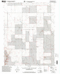
1996 Map of Campo SW
USGS Topo · Published 2000About this map
Comanche National Grassland dominates this corner of Baca County, revealing a landscape defined by an intricate network of drainage systems and intermittent water sources. The topography is carved by numerous canyons, including the divergent branches of North Ute Canyon, West Ute Canyon, and the three distinct forks of Squaw Canyon. This 1996 revision by the USDA Forest Service highlights the area's utility and recreational infrastructure, notably the Picture Canyon Picnic Area and an isolated Pumping Station. These features, alongside scattered wells and gravel pits, underscore the management of these arid lands for both public use and livestock support. The map captures the rugged character of the High Plains before the turn of the millennium, documenting the vital springs and named landforms like Arthurs Canyon and Red Canyon that serve as essential landmarks in this open country.
Find a feature on this map
14 named features on this map. Tap any name to fly to it.
Don’t see what you’re looking for? This feature index may not catch every label — zoom into the map to look around manually.
Map Details
Editions of this 1996 Campo SW Map
This is the sole edition of this map. No revisions or reprints were ever made.
Other maps of this area

1891 · Springfield
USGS Topo · 1:125,000

1893 · Springfield
USGS Topo · 1:125,000

1954 · Dalhart
USGS Topo · 1:250,000

1955 · La Junta
USGS Topo · 1:250,000

1958 · La Junta
USGS Topo · 1:250,000

1958 · Dalhart
USGS Topo · 1:250,000

1962 · Dalhart
USGS Topo · 1:250,000

1968 · La Junta
USGS Topo · 1:250,000

1968 · Autograph Cliff NW
USGS Topo · 1:24,000
1969 · Kenton NE
USGS Topo · 1:24,000