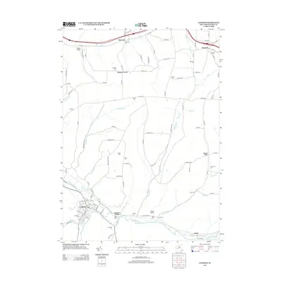
2013 Map of Canisteo
USGS Topo · Published 2013About this map
The Canisteo River valley serves as the primary corridor for development and transport in this part of Steuben County, anchoring the village of Canisteo. The settlement pattern follows the water, with Canisteo Center and Adrian situated along the riverbanks and rail line. Beyond the valley floor, the landscape rises into significant high points like Burt Hill and Horton Hill, where small rural clusters such as Butcher Corner and Buena Vista are connected by a network of county roads. Numerous family and community burial grounds, including Woodlawn Cem, Meeks Cem, and the McConnell Cem, are scattered across the uplands, offering clear markers of long-established lineage for genealogists and local historians. Tributaries such as Bennetts Cr and Stephens Cr cut through the terrain, defining the local geography and the placement of early homesteads like Palmer Farms.
Find a feature on this map
104 named features on this map. Tap any name to fly to it.
Don’t see what you’re looking for? This feature index may not catch every label — zoom into the map to look around manually.
Map Details
Editions of this 2013 Canisteo Map
This is the sole edition of this map. No revisions or reprints were ever made.
Other maps of this area

1910 · Bath
USGS Topo · 1:62,500

1915 · Hornell
USGS Topo · 1:62,500

1918 · Hornell
USGS Topo · 1:62,500

1924 · Woodhull
USGS Topo · 1:48,000

1926 · Woodhull
USGS Topo · 1:62,500

1926 · Greenwood
USGS Topo · 1:62,500

1944 · Woodhull
USGS Topo · 1:62,500

1950 · Elmira
USGS Topo · 1:250,000

1953 · Cameron
USGS Topo · 1:24,000
1953 · Avoca
USGS Topo · 1:24,000