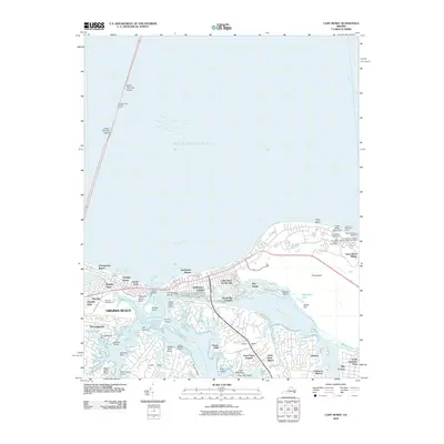
2010 Map of Cape Henry
USGS Topo · Published 2010About this map
Cape Henry serves as a critical navigational and historical anchor at the mouth of the Chesapeake Bay, where the transition from open water to complex tidal inlets defines the landscape. This era shows the developed coastal interface of Virginia Beach, featuring the iconic Old Cape Henry Lighthouse alongside the New Cape Henry Lighthouse and the Cape Henry Memorial Cross. Inland, the intricate waterways of Lynnhaven Bay and the Lynnhaven River create a fragmented geography of points and necks, such as Great Neck and Little Neck, which supported established residential communities like Lynnhaven Shores and Baylake Pines. The map records a sophisticated transportation network that includes the Thimble Shoal Channel Tunnel and the Lesner Bridge, illustrating how mid-20th-century infrastructure managed the confluence of heavy maritime traffic in the Chesapeake Channel with the suburban expansion of the Virginia coast.
Find a feature on this map
82 named features on this map. Tap any name to fly to it.
Don’t see what you’re looking for? This feature index may not catch every label — zoom into the map to look around manually.
Map Details
Editions of this 2010 Cape Henry Map
This is the sole edition of this map. No revisions or reprints were ever made.
Other maps of this area

1893 · Virginia Beach
USGS Topo · 1:125,000

1907 · Norfolk
USGS Topo · 1:125,000

1918 · Cape Henry
USGS Topo · 1:62,500

1919 · Cape Henry
USGS Topo · 1:62,500

1943 · Richmond
USGS Topo · 1:250,000

1946 · Eastville
USGS Topo · 1:250,000

1946 · Currituck Sound
USGS Topo · 1:250,000

1948 · Ocean View
USGS Topo · 1:24,000
1948 · Virginia Beach
USGS Topo · 1:24,000
1948 · Princess Anne
USGS Topo · 1:24,000