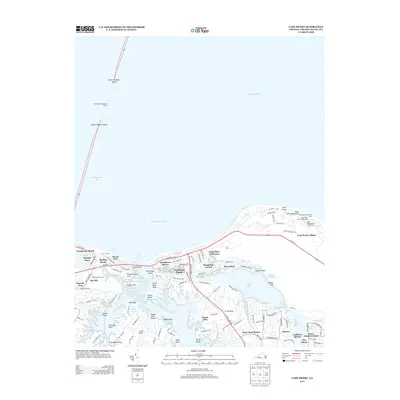
2013 Map of Cape Henry
USGS Topo · Published 2013About this map
The Old Cape Henry Lighthouse and New Cape Henry Lighthouse stand as sentinels at the mouth of the Chesapeake Bay, marking the entrance to one of the Atlantic’s most vital waterways. This coastal landscape is defined by the complex interface of the Lynnhaven River and its various offshoots like Broad Bay and Linkhorn Bay. The map documents the high density of residential development in the early 21st century, with established communities such as Baylake Pines, Lynnhaven Colony, and Cape Story by the Sea filling the peninsula between the bay and the river’s estuaries. Historical markers like the Cape Henry Memorial Cross and the Henry Memorial sit near the shore, while the Thimble Shoal Channel Tunnel provides a critical subterranean link for the region's transport network. The transition from the open waters of Lynnhaven Roads to the protected coves of Great Neck illustrates the geographic diversity of the Virginia Beach coastline.
Find a feature on this map
123 named features on this map. Tap any name to fly to it.
Don’t see what you’re looking for? This feature index may not catch every label — zoom into the map to look around manually.
Map Details
Editions of this 2013 Cape Henry Map
This is the sole edition of this map. No revisions or reprints were ever made.
Other maps of this area

1893 · Virginia Beach
USGS Topo · 1:125,000

1907 · Norfolk
USGS Topo · 1:125,000

1918 · Cape Henry
USGS Topo · 1:62,500

1919 · Cape Henry
USGS Topo · 1:62,500

1943 · Richmond
USGS Topo · 1:250,000

1946 · Eastville
USGS Topo · 1:250,000

1946 · Currituck Sound
USGS Topo · 1:250,000

1948 · Ocean View
USGS Topo · 1:24,000
1948 · Virginia Beach
USGS Topo · 1:24,000
1948 · Princess Anne
USGS Topo · 1:24,000