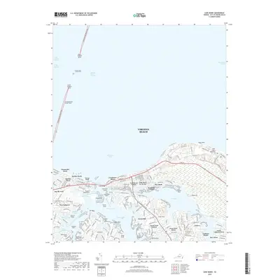
2019 Map of Cape Henry
USGS Topo · Published 2019About this map
Cape Henry serves as the focal point for this coastal survey of the Virginia shoreline where the Atlantic Ocean meets the mouth of the Chesapeake Bay. The landscape is defined by the complex aquatic network of Lynnhaven Bay and Broad Bay, which carve into established residential communities such as Thoroughgood, Baylake Pines, and Alanton. The map shows the modern infrastructure of the Chesapeake Bay Bridge-Tunnel stretching northward, anchored by North Thimble Island and South Thimble Island. To the east, the sprawling undeveloped terrain of The Desert within First Landing State Park provides a stark contrast to the dense suburban street grids of Great Neck Estates and Linkhorn Park. This detailed study preserves the mid-2010s geography of a region balancing maritime heritage at the Cape Henry Memorial with significant 21st-century residential growth.
Find a feature on this map
71 named features on this map. Tap any name to fly to it.
Don’t see what you’re looking for? This feature index may not catch every label — zoom into the map to look around manually.
Map Details
Editions of this 2019 Cape Henry Map
This is the sole edition of this map. No revisions or reprints were ever made.
Other maps of this area

1893 · Virginia Beach
USGS Topo · 1:125,000

1907 · Norfolk
USGS Topo · 1:125,000

1918 · Cape Henry
USGS Topo · 1:62,500

1919 · Cape Henry
USGS Topo · 1:62,500

1943 · Richmond
USGS Topo · 1:250,000

1946 · Eastville
USGS Topo · 1:250,000

1946 · Currituck Sound
USGS Topo · 1:250,000

1948 · Ocean View
USGS Topo · 1:24,000
1948 · Virginia Beach
USGS Topo · 1:24,000
1948 · Princess Anne
USGS Topo · 1:24,000