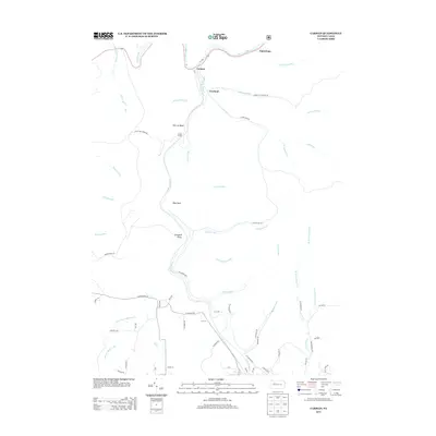
2013 Map of Carman
USGS Topo · Published 2013About this map
Clarion River and Little Toby Cr define this Elk County landscape, where industrial history is etched into the terrain. Near the northern bend of the river, the settlement of Carman sits at a historic junction, while the Empire Tunnel near Elk Lick Bluff serves as a reminder of the subsurface resource extraction that once fueled the local economy. The network of local roads, such as German Settlement Rd and Clay Plant Rd, suggests a lineage of European immigration and manufacturing that shaped the area's development. Landforms like Blue Rock and Vineyard Point provide distinct geographic markers for researchers tracing land tracts. Farther south, Cemetery Hl and the proximity of Croyland offer specific points of interest for genealogists looking to locate family sites within the creek valleys and upland ridges of this section of Pennsylvania.
Find a feature on this map
62 named features on this map. Tap any name to fly to it.
Don’t see what you’re looking for? This feature index may not catch every label — zoom into the map to look around manually.
Map Details
Editions of this 2013 Carman Map
This is the sole edition of this map. No revisions or reprints were ever made.
Other maps of this area

1922 · Du Bois
USGS Topo · 1:62,500

1924 · Du Bois
USGS Topo · 1:62,500

1929 · Penfield
USGS Topo · 1:62,500

1932 · Penfield
USGS Topo · 1:62,500

1940 · Hallton
USGS Topo · 1:48,000

1941 · Ridgway
USGS Topo · 1:62,500

1943 · Hallton
USGS Topo · 1:62,500

1944 · Du Bois
USGS Topo · 1:62,500

1944 · Ridgway
USGS Topo · 1:62,500

1957 · Warren
USGS Topo · 1:250,000
Featured Places
- Spring Creek Township, PA
- Croyland, Spring Creek Township
- Tapawingo, Ridgway Township
- Horton Township, PA
- Polk Township, PA