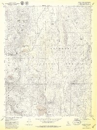
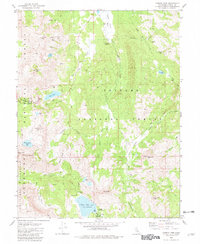
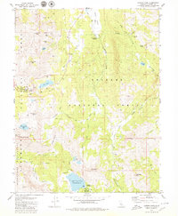
1979 Map of Carson Pass
USGS Topo · Published 1979About this map
Stevens Peak and Hawkins Peak dominate the high-altitude topography of the Sierra Nevada near the border of the Eldorado National Forest and Toiyabe National Forest. The map documents a landscape defined by significant hydrological features and mining history, including the Alpine Mine and Alhambra Mine near Crater Lake. Historically significant markers like the Snowshoe Thompson-Kit Carson (Historical Monuments) stand near the pass, while a lone Grave is noted further south along a trail. Water management is evident at Upper Blue Lake with its recorded Spillway Elevation 8136 and the nearby Damsite Campground. High alpine valleys such as Hope Valley, Charity Valley, and Faith Valley are carved by the West Fork Carson River and its tributaries, providing a detailed record of the region's wilderness and recreational infrastructure in the late 1970s.
Find a feature on this map
56 named features on this map. Tap any name to fly to it.
Don’t see what you’re looking for? This feature index may not catch every label — zoom into the map to look around manually.
Map Details
Editions of this 1979 Carson Pass Map
3 editions found
Other maps of this area

1889 · Pyramid Peak
USGS Topo · 1:125,000

1889 · Markleeville
USGS Topo · 1:125,000

1891 · Markleeville
USGS Topo · 1:125,000

1891 · Pyramid Peak
USGS Topo · 1:125,000

1893 · Markleeville
USGS Topo · 1:125,000

1895 · Pyramid Peak
USGS Topo · 1:125,000

1896 · Pyramid Peak
USGS Topo · 1:125,000

1947 · Sacramento
USGS Topo · 1:250,000

1948 · Walker Lake
USGS Topo · 1:250,000

1948 · Sacramento
USGS Topo · 1:250,000