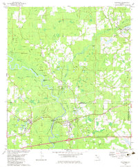
1982 Map of Caryville
USGS Topo · Published 1983About this map
Caryville sits at the crossing of the Seaboard System railroad and the Yellow River, marking a key junction in the Florida Panhandle's river-and-rail corridor. The terrain is defined by a dense network of swampy lowlands and sloughs, including Buckhead Slough and Lawrence Field Slough, which branch away from the main river channel. Small settlements like Westville and Gritney are scattered across the landscape, often positioned near significant hammocks such as Blanchet Field Hammock or along family-named water bodies like Sikes Creek.
Find a feature on this map
71 named features on this map. Tap any name to fly to it.
Don’t see what you’re looking for? This feature index may not catch every label — zoom into the map to look around manually.
Map Details
Editions of this 1982 Caryville Map
This is the sole edition of this map. No revisions or reprints were ever made.
Other maps of this area

1948 · Ponce De Leon
USGS Topo · 1:24,000

1949 · Hinsons Cross Roads
USGS Topo · 1:24,000

1949 · Hobbs Crossroads
USGS Topo · 1:24,000

1949 · Caryville
USGS Topo · 1:24,000

1950 · Hobbs Cross Roads
USGS Topo · 1:24,000

1950 · Prosperity
USGS Topo · 1:24,000

1950 · Ponce De Leon
USGS Topo · 1:24,000

1950 · Hinsons Cross Roads
USGS Topo · 1:24,000

1950 · Caryville
USGS Topo · 1:24,000

1950 · Izagora
USGS Topo · 1:24,000