
Loading...
Loading map...2023 Map of Cassadaga
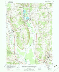
USGS Topo · Published 2023About this map
Lily Dale and the surrounding Chautauqua County lake country are documented here in a modern survey that emphasizes the region's historic village layouts and spiritual heritage. The map centers on the glacial waters of the Cassadaga Lakes, including Mud Lake, which anchor the settlements of Cassadaga and Burnhams. A network of rural cemeteries, such as Christian Cem and Bachelor Cem, are preserved in the landscape alongside more prominent grounds like Evergreen Cem and Greenwood Cem.
Find a feature on this map
84 named features on this map. Tap any name to fly to it.
Don’t see what you’re looking for? This feature index may not catch every label — zoom into the map to look around manually.
Map Details
Date Portrayed2023
Date Published2023
PublisherU.S. Geological Survey
Map TypeTopographic
Scale1:24000
Physical Dimensions24 x 29 inches
Editions of this 2023 Cassadaga Map
This is the sole edition of this map. No revisions or reprints were ever made.
Historical Maps of Village of Sinclairville Through Time
Featured Locations
Source Details
SourceU.S. Geological Survey
CopyrightPublic Domain