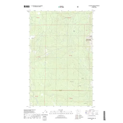
2020 Map of Cavanaugh Creek
USGS Topo · Published 2020About this map
Mount Baker National Forest anchors the eastern edge of this landscape, where the high peaks and drainages of the Twin Sisters Mountain range define the terrain. The map details a complex hydrological network flowing toward the South Fork Nooksack River, featuring numerous named tributaries such as Skookum Cr, Cavanaugh Cr, and Hutchinson Cr. Notable high-altitude landmarks include the broad clearing of Dailey Prairie and several prominent peaks including New York Mtn, Bald Mtn, and Bear Mtn. The presence of Musto Marsh and Atherns Pond provides a contrast to the steep verticality of the surrounding ridges. Infrastructure is sparse, primarily limited to the northwestern corner along Mosquito Lake Rd and Blue Mt Rd, reflecting the remote, resource-focused character of this section of the Whatcom and Skagit county border region.
Find a feature on this map
32 named features on this map. Tap any name to fly to it.
Don’t see what you’re looking for? This feature index may not catch every label — zoom into the map to look around manually.
Map Details
Editions of this 2020 Cavanaugh Creek Map
This is the sole edition of this map. No revisions or reprints were ever made.
Other maps of this area

1909 · Mt Baker
USGS Topo · 1:192,000

1915 · Mt. Baker
USGS Topo · 1:250,000

1919 · Van Zandt
USGS Topo · 1:62,500

1921 · Wickersham
USGS Topo · 1:62,500

1951 · Wickersham
USGS Topo · 1:62,500

1951 · Van Zandt
USGS Topo · 1:62,500

1952 · Mt. Baker
USGS Topo · 1:62,500

1952 · Hamilton
USGS Topo · 1:62,500

1955 · Concrete
USGS Topo · 1:250,000

1957 · Victoria
USGS Topo · 1:250,000