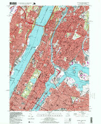
1995 Map of Central Park
USGS Topo · Published 1999About this map
Central Park serves as the geometric anchor of this urban survey, which details the dense verticality and transit infrastructure of Manhattan and the outer boroughs in the mid-1990s. The map captures the city's academic and cultural weight, from the campus of Columbia University to the Metropolitan Museum of Art. Industrial and transport hubs like La Guardia Airport and the Oak Point Yard sit adjacent to residential neighborhoods such as Mott Haven and Steinway.
Find a feature on this map
97 named features on this map. Tap any name to fly to it.
Don’t see what you’re looking for? This feature index may not catch every label — zoom into the map to look around manually.
Map Details
Editions of this 1995 Central Park Map
This is the sole edition of this map. No revisions or reprints were ever made.
Other maps of this area

1888 · Paterson
USGS Topo · 1:62,500

1889 · Brooklyn
USGS Topo · 1:62,500

1891 · Brooklyn
USGS Topo · 1:62,500

1891 · Harlem
USGS Topo · 1:62,500

1892 · Paterson
USGS Topo · 1:62,500

1897 · Harlem
USGS Topo · 1:62,500

1897 · Brooklyn
USGS Topo · 1:62,500

1898 · Harlem
USGS Topo · 1:62,500

1898 · Staten Island
USGS Topo · 1:62,500

1898 · Brooklyn
USGS Topo · 1:62,500