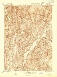
1946 Map of Cheshire
USGS Topo · Published 1946About this map
The Cheshire Reservoir serves as a central valley focal point for this mid-1940s survey of Berkshire County, where the industrial and natural landscapes of Massachusetts converge. The Boston and Albany railroad corridor anchors the eastern valley, connecting the settlements of Cheshire, Berkshire, and Farnams. High-elevation landmarks like Saddle Ball Mountain and Jones Nose overlook the more developed lowlands, illustrating the steep topography that defined local transit and town placement. Local life and industry are marked by the presence of a Quarry near the reservoir and the Stone Sch in Lanesborough. From the northern boundary of Adams down through Dalton, the map reveals a post-war landscape of established mill villages like Maple Grove and Arnoldsville and the intricate drainage of the East Branch and Kitchen Brook.
Find a feature on this map
58 named features on this map. Tap any name to fly to it.
Don’t see what you’re looking for? This feature index may not catch every label — zoom into the map to look around manually.
Map Details
Editions of this 1946 Cheshire Map
This is the sole edition of this map. No revisions or reprints were ever made.
Other maps of this area

1886 · Greylock
USGS Topo · 1:62,500

1886 · Becket
USGS Topo · 1:62,500

1888 · Becket
USGS Topo · 1:62,500

1888 · Berlin
USGS Topo · 1:62,500

1888 · Pittsfield
USGS Topo · 1:62,500

1890 · Pittsfield
USGS Topo · 1:62,500

1890 · Berlin
USGS Topo · 1:62,500

1891 · Greylock
USGS Topo · 1:62,500

1893 · Becket
USGS Topo · 1:62,500

1893 · Greylock
USGS Topo · 1:62,500