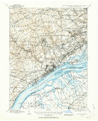
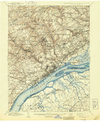
1896 Map of Chester
USGS Topo · Published 1896About this map
Industrial and agrarian life intersect along the Delaware River in this detailed look at the corridor between Philadelphia and Wilmington. The landscape is defined by the heavy rail presence of the Baltimore and Ohio R.R. and the Phila. Wilmington and Baltimore R.R., which fueled the development of riverfront towns like Marcus Hook and Chester. Inland, the terrain is shaped by the steep valleys of Crum Creek and Chester Creek, where numerous milling operations such as Lenni Mills, Llewellyn Mills, and Glen Mills are clustered, signaling the area's manufacturing roots.
Find a feature on this map
188 named features on this map. Tap any name to fly to it.
Don’t see what you’re looking for? This feature index may not catch every label — zoom into the map to look around manually.
Map Details
Editions of this 1896 Chester Map
This is the sole edition of this map. No revisions or reprints were ever made.
Historical Maps of Philadelphia Through Time
3 maps found