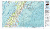
1981 Map of Chincoteague
USGS Topo · Published 1982About this map
Wallops Island and its aerospace facilities, Wallops Station (NASA) and the Wallops Flight Center (NASA), anchor the coast of this 1981 survey of the Delmarva Peninsula. The map details a complex landscape of tidal marshes and barrier islands along the Chesapeake Bay and Pocomoke Sound. Inland, the Penn Central railroad corridor connects a string of Eastern Shore settlements including Parksley, Accomac, and Onancock. Conservation efforts are prominent throughout the region, with the expansive Chincoteague National Wildlife Refuge and Assateague Island National Seashore protecting the outer beaches. Smaller coastal communities like Crisfield and Saxis reflect the maritime economy, while the bathymetric data reveals the shifting shoals of Winter Quarter Shoal and Porpoise Banks just offshore.
Find a feature on this map
80 named features on this map. Tap any name to fly to it.
Don’t see what you’re looking for? This feature index may not catch every label — zoom into the map to look around manually.
Map Details
Editions of this 1981 Chincoteague Map
This is the sole edition of this map. No revisions or reprints were ever made.
Other maps of this area

1898 · St. Marys
USGS Topo · 1:125,000

1901 · Snow Hill
USGS Topo · 1:62,500

1901 · Green Run
USGS Topo · 1:62,500

1903 · Crisfield
USGS Topo · 1:62,500

1903 · Bloodsworth Island
USGS Topo · 1:62,500

1903 · Deal Island
USGS Topo · 1:62,500

1906 · St. Marys
USGS Topo · 1:125,000

1917 · Ewell
USGS Topo · 1:62,500

1920 · Crisfield
USGS Topo · 1:62,500

1931 · Accomac
USGS Topo · 1:48,000