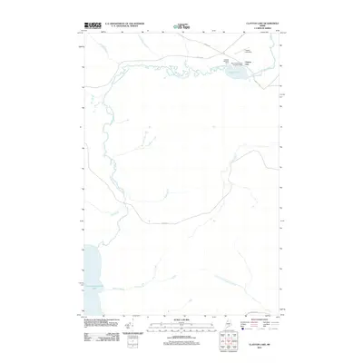
2011 Map of Clayton Lake
USGS Topo · Published 2011About this map
Clayton Lake serves as a remote hub for North Woods operations, anchored by the Clayton Lake Post Office and supporting infrastructure that highlights the region's reliance on air and forest-road transit. The landscape is defined by the winding course of the Chemquasabamticook Stream, which links the larger Chemquasabamticook Lake to the south with the settlement at Clayton Lake. Navigation through this timber-producing interior is facilitated by major private forest routes including Realty Rd, Poulin Rd, and Boise Cascade Rd.
Find a feature on this map
18 named features on this map. Tap any name to fly to it.
Don’t see what you’re looking for? This feature index may not catch every label — zoom into the map to look around manually.
Map Details
Editions of this 2011 Clayton Lake Map
This is the sole edition of this map. No revisions or reprints were ever made.
Other maps of this area

1932 · Umsaskis Lake
USGS Topo · 1:48,000

1935 · Umsaskis Lake
USGS Topo · 1:62,500

1954 · Churchill Lake
USGS Topo · 1:62,500

1954 · Allagash Lake
USGS Topo · 1:62,500

1954 · Presque Isle
USGS Topo · 1:250,000

1955 · Clayton Lake
USGS Topo · 1:62,500

1958 · Presque Isle
USGS Topo · 1:250,000

1960 · Presque Isle
USGS Topo · 1:250,000

1961 · Allagash Lake
USGS Topo · 1:62,500
1962 · Churchill Lake
USGS Topo · 1:62,500
Featured Places
- T10 R14 WELS, ME
- Clayton Lake Township, ME
- T10 R15 WELS, ME
- T11 R15 WELS, ME
- Clayton Lake, Clayton Lake Township