1966 Map of Clover Creek Ranch
USGS Topo · Published 1968About this map
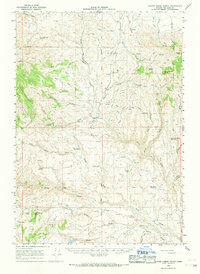
Old Indian Treaty Boundary lines cut through this high desert region of Malheur County, marking historical land divisions across a landscape defined by seasonal water management. Centered on the Clover Creek Ranch, the map reveals a network of remote livestock operations and water control features including the Log Creek Basin Reservoir, Rock Creek Reservoir, and Jenkins Res No 1. The drainage of Bully Creek and its many forks dominate the topography, which is scattered with isolated landmarks like Circle Butte and Juniper Mtn. In a region where accessibility was limited to rugged paths such as the Ferriers Trail and various pack trails, a lone Landing Strip near the primary ranch headquarters provides a rare link to the outside world, illustrating the logistical challenges of mid-century ranching in eastern Oregon.
Find a feature on this map
47 named features on this map. Tap any name to fly to it.
Don’t see what you’re looking for? This feature index may not catch every label — zoom into the map to look around manually.
Map Details
Editions of this 1966 Clover Creek Ranch Map
This is the sole edition of this map. No revisions or reprints were ever made.
Other maps of this area

1908 · Ironside Mountain
USGS Topo · 1:125,000

1955 · Baker
USGS Topo · 1:250,000

1955 · Burns
USGS Topo · 1:250,000

1955 · Canyon City
USGS Topo · 1:250,000

1955 · Boise
USGS Topo · 1:250,000

1958 · Burns
USGS Topo · 1:250,000

1958 · Boise
USGS Topo · 1:250,000

1959 · Baker
USGS Topo · 1:250,000

1959 · Burns
USGS Topo · 1:250,000

1959 · Canyon City
USGS Topo · 1:250,000