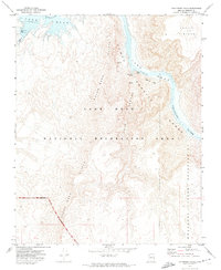
1971 Map of Columbine Falls
USGS Topo · Published 1974About this map
Lake Mead and the Colorado River dominate this 1970s topographical record of Mohave County, where the desert landscape meets the rising waters of the reservoir. The map documents a critical intersection of land management and natural landmarks, showing the Hualapai Indian Reservation boundary set against the Lake Mead National Recreation Area. Geologic and recreational points of interest are numerous along the river corridor, including the Pearce Ferry Boat Anchorage and the sheer Cliffs of the Sanup Plateau. Notable subterranean and hydrological features like Rempart Cave, the Muav Caves, and the eponymous Columbine Falls are precisely located. The map also traces the distinct Granite Gorge and the Grand Wash, illustrating the complex drainage patterns of Cave Canyon before they reach Lower Lake Mead.
Find a feature on this map
20 named features on this map. Tap any name to fly to it.
Don’t see what you’re looking for? This feature index may not catch every label — zoom into the map to look around manually.
Map Details
Editions of this 1971 Columbine Falls Map
This is the sole edition of this map. No revisions or reprints were ever made.
Other maps of this area

1886 · Diamond Creek
USGS Topo · 1:250,000

1886 · Camp Mohave
USGS Topo · 1:250,000

1886 · Saint Thomas
USGS Topo · 1:250,000

1886 · Mt. Trumbull
USGS Topo · 1:250,000

1892 · Diamond Creek
USGS Topo · 1:250,000

1892 · Mt. Trumbull
USGS Topo · 1:250,000

1892 · Camp Mohave
USGS Topo · 1:250,000

1893 · Saint Thomas
USGS Topo · 1:250,000

1926 · Bonelli
USGS Topo · 1:96,000

1942 · Camp Mohave
USGS Topo · 1:250,000