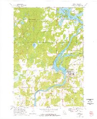
1973 Map of Cornell
USGS Topo · Published 1977About this map
The Chippewa River anchors this mid-1970s landscape, flowing past the industrial and civic center of Cornell before winding south. The river's path is heavily influenced by the Holcombe Dam, which regulates the expansive Lake Holcombe flowage to the north. This era captures the transition of the local infrastructure, where the Chicago and North Western tracks parallel the water, while an Old Railroad Grade to the east suggests an earlier era of timber or freight transport that has since evolved.
Find a feature on this map
30 named features on this map. Tap any name to fly to it.
Don’t see what you’re looking for? This feature index may not catch every label — zoom into the map to look around manually.
Map Details
Editions of this 1973 Cornell Map
This is the sole edition of this map. No revisions or reprints were ever made.
Other maps of this area

1948 · Weyerhauser
USGS Topo · 1:48,000

1948 · Ladysmith
USGS Topo · 1:48,000

1949 · Bloomer
USGS Topo · 1:62,500

1950 · Weyerhauser
USGS Topo · 1:48,000

1950 · Ladysmith
USGS Topo · 1:48,000

1951 · Bloomer
USGS Topo · 1:62,500

1951 · Cornell
USGS Topo · 1:62,500

1953 · Rice Lake
USGS Topo · 1:250,000

1959 · Rice Lake
USGS Topo · 1:250,000
1971 · Ladysmith SE
USGS Topo · 1:24,000