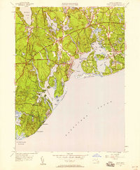
1949 Map of Cotuit
USGS Topo · Published 1958About this map
Mashpee and the surrounding villages of Santuit and Marstons Mills define this coastal landscape on the edge of Nantucket Sound. The 1949 revision details a complex network of freshwater kettle ponds, such as Mashpee Pond and Santuit Pond, set against the jagged shoreline of Poponesset Bay and Cotuit Bay. Cultural landmarks of the mid-century era are well-documented, including the Old Indian Ch, the Santuit Golf Course, and Camp Cotuit. On the eastern shore, the development of Grand Island Oyster Harbors and Wianno illustrates the coastal evolution of the area. Notable local infrastructure, from the Pumping Sta near Lovells Pond to the clustered family-oriented burial grounds like Marstons Mills Cem and Moss Wood Cem, provides a grounded view of the community's mid-century footprint before later suburban expansion.
Find a feature on this map
84 named features on this map. Tap any name to fly to it.
Don’t see what you’re looking for? This feature index may not catch every label — zoom into the map to look around manually.
Map Details
Editions of this 1949 Cotuit Map
This is the sole edition of this map. No revisions or reprints were ever made.
Other maps of this area

1886 · Falmouth
USGS Topo · 1:62,500

1888 · Barnstable
USGS Topo · 1:62,500

1888 · Falmouth
USGS Topo · 1:62,500

1893 · Barnstable
USGS Topo · 1:62,500

1893 · Falmouth
USGS Topo · 1:62,500

1915 · Falmouth
USGS Topo · 1:62,500

1920 · Falmouth
USGS Topo · 1:62,500
1935 · Pocasset
USGS Topo · 1:20,000
1936 · Falmouth
USGS Topo · 1:25,000

1938 · Sandwich
USGS Topo · 1:31,680