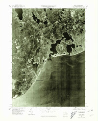
1977 Map of Cotuit
USGS Topo · Published 1981About this map
Mashpee and the surrounding coastal reaches of Cape Cod are presented in this 1977 orthophotoquad, which utilizes rectified aerial photography to reveal the intricate relationship between the land and the Atlantic. The intricate shoreline of Osterville and the sheltered waters of Cotuit are visible in high detail, showing the developed residential patterns of the late 1970s. Along the southern edge, Popponesset Beach fronts the Nantucket Sound, where the shifting sands of The Neck protect the inner estuaries. This photographic perspective offers a unique view of the region's transition from the wooded interior around Pine Tree Corner to the dense coastal settlements at South Mashpee. Unlike a traditional line-drawn map, this imagery preserves the exact footprint of every dock, driveway, and clearing as they existed in the spring of 1977.
Find a feature on this map
8 named features on this map. Tap any name to fly to it.
Don’t see what you’re looking for? This feature index may not catch every label — zoom into the map to look around manually.
Map Details
Editions of this 1977 Cotuit Map
This is the sole edition of this map. No revisions or reprints were ever made.
Other maps of this area

1886 · Falmouth
USGS Topo · 1:62,500

1888 · Barnstable
USGS Topo · 1:62,500

1888 · Falmouth
USGS Topo · 1:62,500

1893 · Barnstable
USGS Topo · 1:62,500

1893 · Falmouth
USGS Topo · 1:62,500

1915 · Falmouth
USGS Topo · 1:62,500

1920 · Falmouth
USGS Topo · 1:62,500
1935 · Pocasset
USGS Topo · 1:20,000
1936 · Falmouth
USGS Topo · 1:25,000

1938 · Sandwich
USGS Topo · 1:31,680