
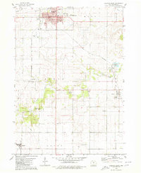
1979 Map of Coulter
USGS Topo · Published 1980About this map
Coulter anchors the northwestern corner of this Franklin County survey, showing the town's grid and its relationship to the surrounding agricultural landscape in the late 1970s. The region is defined by its transit history, particularly the Chicago and North Western Railroad Grade in the north and the active Chicago Rock Island and Pacific tracks in the southeast. Waterways like Maynes Creek and Squaw Creek carve through the prairie townships of Marion, Hamilton, and Mott, where small rural landmarks persist. Genealogists will find interest in the locations of St Johns Ch and the Maynes Grove Cem, alongside a centrally located Townhall and the small station of Klousia. A Pipeline and a Radio Tower mark the technological footprint of the era, while a Landing Strip provides a look at local private aviation.
Find a feature on this map
20 named features on this map. Tap any name to fly to it.
Don’t see what you’re looking for? This feature index may not catch every label — zoom into the map to look around manually.
Map Details
Editions of this 1979 Coulter Map
This is the sole edition of this map. No revisions or reprints were ever made.
Other maps of this area

1954 · Waterloo
USGS Topo · 1:250,000

1955 · Waterloo
USGS Topo · 1:250,000

1972 · Alexander
USGS Topo · 1:24,000

1972 · Latimer
USGS Topo · 1:24,000

1972 · Hampton North
USGS Topo · 1:24,000

1979 · Dows East
USGS Topo · 1:24,000

1979 · Iowa Falls West
USGS Topo · 1:24,000

1979 · Popejoy
USGS Topo · 1:24,000

1979 · Iowa Falls East
USGS Topo · 1:24,000
1979 · Hampton South
USGS Topo · 1:24,000