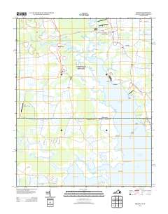
2013 Map of Creeds
USGS Topo · Published 2013About this map
Pungo Ferry and the small coastal settlements of Creeds and Blackwater define this reach of the Virginia-North Carolina borderlands. The landscape is a network of slow-moving waterways and low-lying landforms, where the North Landing River flows into the Atlantic Ocean and Tull Bay. Human activity is clustered around these water features, with Bingo Berry Marina serving as a local waypoint and the Knight's Landing LLC Airport providing inland access.
Find a feature on this map
69 named features on this map. Tap any name to fly to it.
Don’t see what you’re looking for? This feature index may not catch every label — zoom into the map to look around manually.
Map Details
Editions of this 2013 Creeds Map
This is the sole edition of this map. No revisions or reprints were ever made.
Other maps of this area

1893 · Virginia Beach
USGS Topo · 1:125,000

1916 · Back Bay
USGS Topo · 1:62,500

1939 · Moyock
USGS Topo · 1:62,500

1940 · Barco
USGS Topo · 1:62,500

1943 · Back Bay
USGS Topo · 1:62,500

1946 · Moyock
USGS Topo · 1:62,500

1946 · Eastville
USGS Topo · 1:250,000

1946 · Currituck Sound
USGS Topo · 1:250,000

1948 · Elizabeth City
USGS Topo · 1:62,500

1953 · Norfolk
USGS Topo · 1:250,000