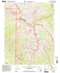
2001 Map of Crestone Peak
USGS Topo · Published 2005About this map
The Sangre de Cristo Mountains dominate this high-altitude landscape, where sharp summits like Crestone Peak and Crestone Needle rise along the county boundary. The map illustrates a complex intersection of land management, featuring the eastern edge of the Luis Maria Baca Grant No 4 and the preserved expanses of the Sangre de Cristo Wilderness. Natural drainage patterns are clearly defined by Sand Creek, Macey Creek, and the headwaters of Rio Grande Creek, which feed into alpine basins such as Upper Sand Creek Lake and the Macey Lakes. Evidence of mineral exploration appears in the western gulches, where several Mines and Prospects are recorded near Cedar Canyon and Milwaukee Hill. These mining efforts stand in contrast to the protected wilderness and the edges of the Great Sand Dunes National Preserve, highlighting the area's dual history of resource extraction and early 21st-century conservation.
Find a feature on this map
59 named features on this map. Tap any name to fly to it.
Don’t see what you’re looking for? This feature index may not catch every label — zoom into the map to look around manually.
Map Details
Editions of this 2001 Crestone Peak Map
This is the sole edition of this map. No revisions or reprints were ever made.
Other maps of this area

1889 · Canon City
USGS Topo · 1:125,000

1889 · Huerfano Park
USGS Topo · 1:125,000

1892 · Huerfano Park
USGS Topo · 1:125,000

1892 · Canon City
USGS Topo · 1:125,000

1954 · Trinidad
USGS Topo · 1:250,000

1954 · Pueblo
USGS Topo · 1:250,000

1955 · Trinidad
USGS Topo · 1:250,000

1957 · Pueblo
USGS Topo · 1:250,000

1957 · Aldrich Gulch
USGS Topo · 1:24,000

1958 · Trinidad
USGS Topo · 1:250,000