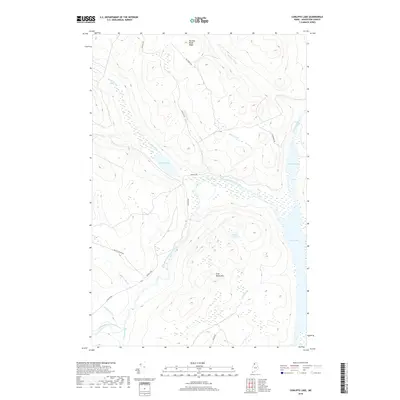
2018 Map of Cunliffe Lake
USGS Topo · Published 2018About this map
Allagash River drainage and the surrounding timberlands of northern Aroostook County dominate this 2018 study. The landscape is defined by its complex hydrography, where Long Lake and Harvey Pond are connected by a network of waterways including the Chemquasabamticook Stream. The map reveals the modern infrastructure of the working forest, showing how Cunliffe Rd, California Rd, and McNally Rd navigate the high ground of Harding Brook Ridge and Grey Brook Mtn. These roads provide access to isolated water bodies like Cunliffe Lake and Grey Pond, illustrating the ongoing industrial and recreational use of this remote Maine territory. Small tributaries such as Priestly Brook and Gilbert Brook feed into the larger river systems, shaping a terrain that remains largely undeveloped except for this grid of forest management routes.
Find a feature on this map
21 named features on this map. Tap any name to fly to it.
Don’t see what you’re looking for? This feature index may not catch every label — zoom into the map to look around manually.
Map Details
Editions of this 2018 Cunliffe Lake Map
This is the sole edition of this map. No revisions or reprints were ever made.
Other maps of this area

1932 · Umsaskis Lake
USGS Topo · 1:48,000

1935 · Umsaskis Lake
USGS Topo · 1:62,500

1954 · Presque Isle
USGS Topo · 1:250,000

1955 · Round Pond
USGS Topo · 1:62,500

1955 · Clayton Lake
USGS Topo · 1:62,500

1955 · Seven Islands
USGS Topo · 1:62,500

1958 · Presque Isle
USGS Topo · 1:250,000

1960 · Presque Isle
USGS Topo · 1:250,000

1976 · Seven Islands
USGS Topo · 1:24,000
1986 · Seven Islands
USGS Topo · 1:24,000