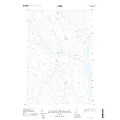
2021 Map of Cunliffe Lake
USGS Topo · Published 2021About this map
Allagash River waters define the eastern edge of this northern Maine landscape, where the river widens into Long Lake and the smaller Harvey Pond. This modern survey reveals a dense network of logging and access roads, including Cunliffe Rd and Realty Rd, which navigate the high ground of Harding Brook Ridge and the flanks of Grey Brook Mtn. The hydrology of the region is complex, dominated by the Chemquasabamticook Stream as it winds toward the larger water bodies. The map illustrates a commercial forest environment where named features like Cunliffe Lake and Grey Pond are connected by a system of smaller tributaries including Caron Brook, Holmes Brook, and Gilbert Brook. This layout highlights the contemporary intersection of remote wilderness management and the industrial road networks required for timber transport in Aroostook County.
Find a feature on this map
21 named features on this map. Tap any name to fly to it.
Don’t see what you’re looking for? This feature index may not catch every label — zoom into the map to look around manually.
Map Details
Editions of this 2021 Cunliffe Lake Map
This is the sole edition of this map. No revisions or reprints were ever made.
Other maps of this area

1932 · Umsaskis Lake
USGS Topo · 1:48,000

1935 · Umsaskis Lake
USGS Topo · 1:62,500

1954 · Presque Isle
USGS Topo · 1:250,000

1955 · Round Pond
USGS Topo · 1:62,500

1955 · Clayton Lake
USGS Topo · 1:62,500

1955 · Seven Islands
USGS Topo · 1:62,500

1958 · Presque Isle
USGS Topo · 1:250,000

1960 · Presque Isle
USGS Topo · 1:250,000

1976 · Seven Islands
USGS Topo · 1:24,000
1986 · Seven Islands
USGS Topo · 1:24,000