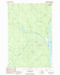
1986 Map of Cunliffe Lake
USGS Topo · Published 1987About this map
Allagash Wilderness State Waterway defines the eastern corridor of this remote Aroostook County landscape, where the Chemquasabamticook Stream winds through dense timberlands to meet the southern reaches of Long Lake. This mid-1980s survey captures a working wilderness characterized by a network of private roads used for logging operations, connecting isolated features like a Gravel Pit near the center of the map. The terrain is anchored by Grey Mountain, which rises between Grey Pond and Carlopons Pond. Further west, Cunliffe Lake sits as a significant water body fed by Cunliffe Brook. The map details the complex drainage system of the North Maine Woods, including Harvey Pond and numerous brooks like Harding Brook and Whittaker Brook, illustrating the area's geography before modern digital mapping. The township boundaries, such as T 12 R 13 W E L S, reflect the historical survey grid of the Maine Public Reserved Lands.
Find a feature on this map
25 named features on this map. Tap any name to fly to it.
Don’t see what you’re looking for? This feature index may not catch every label — zoom into the map to look around manually.
Map Details
Editions of this 1986 Cunliffe Lake Map
This is the sole edition of this map. No revisions or reprints were ever made.
Other maps of this area

1932 · Umsaskis Lake
USGS Topo · 1:48,000

1935 · Umsaskis Lake
USGS Topo · 1:62,500

1954 · Presque Isle
USGS Topo · 1:250,000

1955 · Round Pond
USGS Topo · 1:62,500

1955 · Clayton Lake
USGS Topo · 1:62,500

1955 · Seven Islands
USGS Topo · 1:62,500

1958 · Presque Isle
USGS Topo · 1:250,000

1960 · Presque Isle
USGS Topo · 1:250,000

1976 · Seven Islands
USGS Topo · 1:24,000
1986 · Seven Islands
USGS Topo · 1:24,000