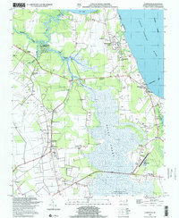
1999 Map of Currituck
USGS Topo · Published 2002About this map
Currituck stands as a focal point along the eastern shore of this coastal landscape, situated where the Knotts Island Ferry departs across the waters. The interior transitions from the low-lying Great Swamp and the dense network of Tull Creek and Cowells Creek to agricultural lands dotted with small crossroads settlements like Sligo, Shawboro, and Maple. Evidence of local community life is found in the many rural churches and family cemeteries, including Good Hope Zion Ch, Weeping Mary Ch, and Perkins United Ch.
Find a feature on this map
35 named features on this map. Tap any name to fly to it.
Don’t see what you’re looking for? This feature index may not catch every label — zoom into the map to look around manually.
Map Details
Editions of this 1999 Currituck Map
This is the sole edition of this map. No revisions or reprints were ever made.
Other maps of this area

1893 · Virginia Beach
USGS Topo · 1:125,000

1916 · Back Bay
USGS Topo · 1:62,500

1939 · Moyock
USGS Topo · 1:62,500

1940 · Barco
USGS Topo · 1:62,500

1943 · Back Bay
USGS Topo · 1:62,500

1946 · Moyock
USGS Topo · 1:62,500

1946 · Eastville
USGS Topo · 1:250,000

1946 · Currituck Sound
USGS Topo · 1:250,000

1948 · Elizabeth City
USGS Topo · 1:62,500

1953 · Norfolk
USGS Topo · 1:250,000