Loading...
Loading map...1921 Map of Dauphin Island
USGS Topo · Published 1921About this map
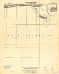
Military fortifications and maritime navigation markers define the entrance to Mobile Bay in this tactical survey. Fort Morgan stands prominently on Mobile Point, accompanied by a Quarantine Sta. and the complex shoals of the South Bank. Across the Main Ship Channel, Fort Gaines guards the eastern tip of Dauphin Island, overlooking the shifting sands of Dauphin Id. Spit.
Find a feature on this map
23 named features on this map. Tap any name to fly to it.
Don’t see what you’re looking for? This feature index may not catch every label — zoom into the map to look around manually.
Map Details
Date Portrayed1921
Date Published1921
PublisherU.S. Geological Survey
Map TypeTopographic
Scale1:62,500
Physical Dimensions17.03 x 21.41 inches
Editions of this 1921 Dauphin Island Map
This is the sole edition of this map. No revisions or reprints were ever made.
Historical Maps of Dauphin Island Through Time

Featured Locations
Source Details
SourceU.S. Geological Survey
CopyrightPublic Domain