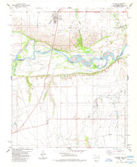
1985 Map of Davidson
USGS Topo · Published 1985About this map
Davidson serves as the focal point of this mid-1980s survey, situated north of the braided channels where the Red River marks the Oklahoma-Texas border. The landscape is defined by the hydrologic complexity of the river valley, where an indefinite boundary snakes through shifting sandbars and islands, met by the confluence with the Pease River. This era shows the infrastructure of the southern Great Plains, from the Burlington Northern line moving through town to the scattered wells and agricultural outposts like Elliott.
Find a feature on this map
19 named features on this map. Tap any name to fly to it.
Don’t see what you’re looking for? This feature index may not catch every label — zoom into the map to look around manually.
Map Details
Editions of this 1985 Davidson Map
This is the sole edition of this map. No revisions or reprints were ever made.
Other maps of this area

1916 · Electra
USGS Topo · 1:24,000

1918 · Electra
USGS Topo · 1:31,680

1955 · Lawton
USGS Topo · 1:250,000

1958 · Davidson
USGS Topo · 1:62,500

1958 · Frederick
USGS Topo · 1:62,500

1958 · Electra
USGS Topo · 1:62,500
1972 · Electra
USGS Topo · 1:24,000

1974 · Hackberry Flat
USGS Topo · 1:24,000

1975 · Frederick SW
USGS Topo · 1:24,000

1975 · Frederick SE
USGS Topo · 1:24,000