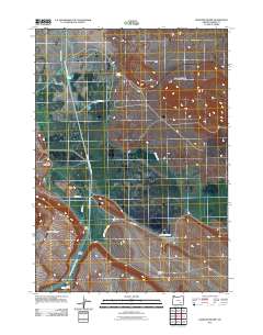
2011 Map of Diamond Swamp
USGS Topo · Published 2011About this map
The Donner und Blitzen River winds through the expansive Blitzen Valley, where a complex system of agricultural irrigation is evident through features like Skunk Farm Canal, Center Canal, and the East Grain Camp Canal. This 2011 survey of Harney County highlights a landscape shaped by both hydrology and volcanic activity, most notably at the Diamond Craters in the northeast and prominent elevations such as Jackass Mountain and Buena Vista Butte. Settlement in this high desert region is sparse, anchored by the Grain Camp and Anderson Ranch, which sit along transit routes like Center Patrol Rd and Diamond Ln. These landmarks reflect the long-standing ranching and water management traditions essential for life in this arid basin.
Find a feature on this map
16 named features on this map. Tap any name to fly to it.
Don’t see what you’re looking for? This feature index may not catch every label — zoom into the map to look around manually.
Map Details
Editions of this 2011 Diamond Swamp Map
This is the sole edition of this map. No revisions or reprints were ever made.
Other maps of this area

1955 · Burns
USGS Topo · 1:250,000

1955 · Adel
USGS Topo · 1:250,000

1957 · Adel
USGS Topo · 1:250,000

1958 · Burns
USGS Topo · 1:250,000

1958 · Adel
USGS Topo · 1:250,000

1959 · Burns
USGS Topo · 1:250,000

1962 · Adel
USGS Topo · 1:250,000

1967 · Coyote Buttes
USGS Topo · 1:24,000

1967 · Krumbo Reservoir
USGS Topo · 1:24,000

1967 · Jackass Butte
USGS Topo · 1:24,000