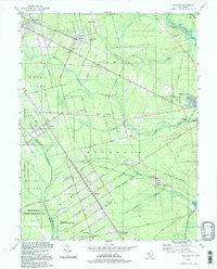
1994 Map of Dorothy
USGS Topo · Published 1998About this map
Great Egg Harbor River flows through the northeast corner of this Atlantic County landscape, where the pine forests are marked by an organized grid of early settlement roads. The community of Dorothy serves as a central hub for the Weymouth area, characterized by a series of numbered avenues like Eleventh Avenue and Sixteenth Avenue that intersect the long diagonal of the Atlantic and Cumberland County line.
Find a feature on this map
42 named features on this map. Tap any name to fly to it.
Don’t see what you’re looking for? This feature index may not catch every label — zoom into the map to look around manually.
Map Details
Editions of this 1994 Dorothy Map
This is the sole edition of this map. No revisions or reprints were ever made.
Other maps of this area

1890 · Great Egg Harbor
USGS Topo · 1:62,500

1890 · Hammonton
USGS Topo · 1:62,500

1890 · Tuckahoe
USGS Topo · 1:62,500

1890 · Mullica
USGS Topo · 1:62,500

1893 · Great Egg Harbor
USGS Topo · 1:62,500

1893 · Tuckahoe
USGS Topo · 1:62,500

1894 · Hammonton
USGS Topo · 1:62,500

1894 · Mullica
USGS Topo · 1:62,500

1898 · Mullica
USGS Topo · 1:62,500

1898 · Hammonton
USGS Topo · 1:62,500
Featured Places
- Hamilton Township, NJ
- Maurice River Township, NJ
- Buena Vista Township, NJ
- Weymouth Township, NJ
- Estell Manor, NJ