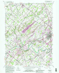
1992 Map of Doylestown
USGS Topo · Published 1995About this map
Neshaminy Creek and its many tributaries, including the North Branch and Pine Run, weave through this portion of central Bucks County. The landscape is defined by the massive Peace Valley Reservoir and a pattern of small historical settlements like New Britain, Chalfont, and Edison. This late 20th-century revision captures the intersection of traditional agricultural land and increasing suburban density, visible in the cluster of institutions such as the Delaware Valley College of Science and Agriculture and the Bucks County Home.
Find a feature on this map
68 named features on this map. Tap any name to fly to it.
Don’t see what you’re looking for? This feature index may not catch every label — zoom into the map to look around manually.
Map Details
Editions of this 1992 Doylestown Map
This is the sole edition of this map. No revisions or reprints were ever made.
Other maps of this area

1888 · Quakertown
USGS Topo · 1:62,500

1890 · Doylestown
USGS Topo · 1:62,500

1890 · Quakertown
USGS Topo · 1:62,500

1891 · Doylestown
USGS Topo · 1:62,500

1893 · Germantown
USGS Topo · 1:62,500

1894 · Quakertown
USGS Topo · 1:62,500

1894 · Norristown
USGS Topo · 1:62,500

1894 · Germantown
USGS Topo · 1:62,500

1895 · Norristown
USGS Topo · 1:62,500

1896 · Germantown
USGS Topo · 1:62,500
Featured Places
- Warrington Township, PA
- Buckingham Township, PA
- Hilltown Township, PA
- Doylestown, PA
- Bedminster Township, PA