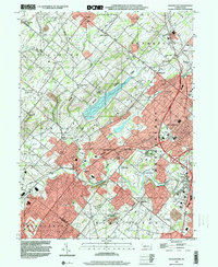
1999 Map of Doylestown
USGS Topo · Published 2001About this map
Doylestown serves as the focal point of this late 20th-century landscape, surrounded by a dense network of suburban development and historical educational institutions. The map highlights the sprawling campus of the Delaware Valley College of Science and Agriculture and the nearby Farm School, reflecting the region's transition from rural agriculture to an institutional and residential hub. The massive Peace Valley Reservoir dominates the central terrain, having reshaped the local geography near the historic site of New Galena.
Find a feature on this map
58 named features on this map. Tap any name to fly to it.
Don’t see what you’re looking for? This feature index may not catch every label — zoom into the map to look around manually.
Map Details
Editions of this 1999 Doylestown Map
This is the sole edition of this map. No revisions or reprints were ever made.
Other maps of this area

1888 · Quakertown
USGS Topo · 1:62,500

1890 · Doylestown
USGS Topo · 1:62,500

1890 · Quakertown
USGS Topo · 1:62,500

1891 · Doylestown
USGS Topo · 1:62,500

1893 · Germantown
USGS Topo · 1:62,500

1894 · Quakertown
USGS Topo · 1:62,500

1894 · Norristown
USGS Topo · 1:62,500

1894 · Germantown
USGS Topo · 1:62,500

1895 · Norristown
USGS Topo · 1:62,500

1896 · Germantown
USGS Topo · 1:62,500
Featured Places
- Warrington Township, PA
- Buckingham Township, PA
- Hilltown Township, PA
- Doylestown, PA
- Bedminster Township, PA