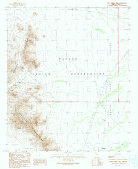
1990 Map of Drew Spring Well
USGS Topo · Published 1990About this map
The Cimarron Mountains and Sheridan Mountains dominate the western half of this 1990 survey, rising sharply from the desert floor of the Papago Indian Reservation. This landscape is marked by a history of mineral exploration, with numerous small-scale operations including the Montazona Mine, Blackjack Mine, and Oro Grande Mine scattered along the mountain flanks. These sites, along with various prospects, adits, and a mine shaft, suggest a period of active geological testing and extraction in this remote corner of Pima County.
Find a feature on this map
21 named features on this map. Tap any name to fly to it.
Don’t see what you’re looking for? This feature index may not catch every label — zoom into the map to look around manually.
Map Details
Editions of this 1990 Drew Spring Well Map
This is the sole edition of this map. No revisions or reprints were ever made.
Other maps of this area

1934 · Silver Bell
USGS Topo · 1:125,000

1941 · Vekol Mountains
USGS Topo · 1:62,500

1942 · Silver Reef Mountains
USGS Topo · 1:62,500

1942 · Vekol Mountains
USGS Topo · 1:62,500

1953 · Ajo
USGS Topo · 1:250,000

1956 · Tucson
USGS Topo · 1:250,000

1957 · Ajo
USGS Topo · 1:250,000

1958 · Ajo
USGS Topo · 1:250,000

1958 · Tucson
USGS Topo · 1:250,000

1959 · Tucson
USGS Topo · 1:250,000