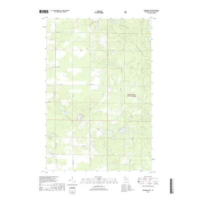
2018 Map of Drummond NW
USGS Topo · Published 2018About this map
Chequamegon National Forest dominates this landscape in the northern Wisconsin woods, where a dense network of glacial lakes and wetlands creates a pocketed terrain. The northern reaches are traversed by the N Country National Scenic Trail, which winds past Camp Two Lake, Trout Lake, and Silver Lake. The map reveals a transition between managed forest lands and small water bodies, with several lakes bearing names that suggest old logging or recreational origins, such as Camp Nine Lake and Wilderness Lake. Transportation is defined by a grid of rural routes including Co Hwy A and Webster Rd, which provide access to more remote locations like West Eightmile Lake and the Ducetts Lakes. This 2018 survey serves as a modern record of the interior forest roads and trail systems that define current land use in Bayfield County.
Find a feature on this map
25 named features on this map. Tap any name to fly to it.
Don’t see what you’re looking for? This feature index may not catch every label — zoom into the map to look around manually.
Map Details
Editions of this 2018 Drummond NW Map
This is the sole edition of this map. No revisions or reprints were ever made.
Other maps of this area

1943 · Iron Lake
USGS Topo · 1:48,000

1944 · Drummond
USGS Topo · 1:48,000

1945 · Highland
USGS Topo · 1:48,000

1947 · Drummond
USGS Topo · 1:48,000

1947 · Brule
USGS Topo · 1:48,000

1947 · Iron Lake
USGS Topo · 1:48,000

1949 · Highland
USGS Topo · 1:48,000

1953 · Ashland
USGS Topo · 1:250,000

1958 · Ashland
USGS Topo · 1:250,000

1961 · Iron Lake SW
USGS Topo · 1:24,000