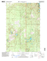
2005 Map of Drummond NW
USGS Topo · Published 2006About this map
Chequamegon National Forest dominates this northern Wisconsin landscape, where the town lines of Hughes, Barnes, and Drummond converge. This 2005 revision highlights a dense network of glacial water bodies, from the paired West Eightmile Lake and East Eightmile Lake to the more secluded Wilderness Lake and Nancy Lake. The terrain is defined by its lack of dense development, favoring a system of forest access ways such as Scenic Road and Webster Road. Researchers will find a preserved wilderness character, with labels like Camp Nine Lake and Ducetts Lakes suggesting the area's recreational and sporting legacy. The map provides clear evidence of how the Chequamegon National Forest has maintained the region's original glacial topography and hydrography into the modern era.
Find a feature on this map
27 named features on this map. Tap any name to fly to it.
Don’t see what you’re looking for? This feature index may not catch every label — zoom into the map to look around manually.
Map Details
Editions of this 2005 Drummond NW Map
This is the sole edition of this map. No revisions or reprints were ever made.
Other maps of this area

1943 · Iron Lake
USGS Topo · 1:48,000

1944 · Drummond
USGS Topo · 1:48,000

1945 · Highland
USGS Topo · 1:48,000

1947 · Drummond
USGS Topo · 1:48,000

1947 · Brule
USGS Topo · 1:48,000

1947 · Iron Lake
USGS Topo · 1:48,000

1949 · Highland
USGS Topo · 1:48,000

1953 · Ashland
USGS Topo · 1:250,000

1958 · Ashland
USGS Topo · 1:250,000

1961 · Iron Lake SW
USGS Topo · 1:24,000