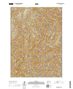
2020 Map of Dutchman Butte
USGS Topo · Published 2020About this map
Dutchman Butte and the surrounding peaks of Ninemile Mtn define a complex landscape where the boundaries of Douglas, Curry, and Josephine counties converge. This 2020 survey illustrates a contemporary network of forest access roads and spurs, including the Panther Ridge Mainline and Dutch Henry Rd, which navigate the steep drainage systems of W Fork Cow Cr and Dutchman Cr. The presence of the Calvert Peak Airport at these high elevations indicates the importance of aerial access for fire management or regional logistics in this heavily wooded terrain.
Find a feature on this map
54 named features on this map. Tap any name to fly to it.
Don’t see what you’re looking for? This feature index may not catch every label — zoom into the map to look around manually.
Map Details
Editions of this 2020 Dutchman Butte Map
This is the sole edition of this map. No revisions or reprints were ever made.
Other maps of this area

1946 · Galice
USGS Topo · 1:62,500

1946 · Dutchman Butte
USGS Topo · 1:62,500

1948 · Galice
USGS Topo · 1:62,500

1948 · Dutchman Butte
USGS Topo · 1:62,500

1954 · Bone Mountain
USGS Topo · 1:62,500

1954 · Marial
USGS Topo · 1:62,500

1955 · Medford
USGS Topo · 1:250,000

1957 · Medford
USGS Topo · 1:250,000

1958 · Medford
USGS Topo · 1:250,000
1989 · Kelsey Peak
USGS Topo · 1:24,000