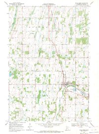
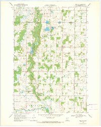
1969 Map of Eagle Bend
USGS Topo · Published 1971About this map
The Eagle Valley landscape of Todd County is defined by the convergence of several waterways and the presence of the Burlington Northern railroad in the late 1960s. The village of Eagle Bend serves as the central hub of this agricultural region, situated where Eagle Creek meets the valley floor. The map reveals a high density of small local burial grounds, including Hope Cem, German Cem, and the St Johns Cem to the north, which provide significant data points for genealogists tracing family histories in the townships of Bertha, Germania, and Wykeham. Numerous gravel pits and the meandering courses of the Wing River and Partridge River illustrate the glacial topography that shaped the local economy. The transition from prairie to wetlands is evident near Pendergast Lake and the various unnamed marshes that dot the terrain between the river systems.
Find a feature on this map
18 named features on this map. Tap any name to fly to it.
Don’t see what you’re looking for? This feature index may not catch every label — zoom into the map to look around manually.
Map Details
Editions of this 1969 Eagle Bend Map
This is the sole edition of this map. No revisions or reprints were ever made.
Other maps of this area

1953 · Brainerd
USGS Topo · 1:250,000

1957 · Brainerd
USGS Topo · 1:250,000

1958 · Brainerd
USGS Topo · 1:250,000

1965 · Brainerd
USGS Topo · 1:250,000
1966 · Clarissa
USGS Topo · 1:24,000
1966 · Browerville SW
USGS Topo · 1:24,000

1966 · Aldrich South
USGS Topo · 1:24,000
1969 · Clotho
USGS Topo · 1:24,000
1969 · Rose City
USGS Topo · 1:24,000

1969 · Bertha
USGS Topo · 1:24,000